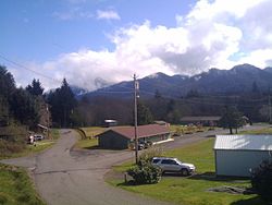
Amanda Park, Washington
Amanda Park, Washington | |
|---|---|
 View of Amanda Park | |
| Coordinates: 47°27′32″N 123°53′31″W / 47.45889°N 123.89194°W | |
| Country | United States |
| State | Washington |
| County | Grays Harbor |
| Area | |
• Total | 8.5 sq mi (22.0 km2) |
| • Land | 8.2 sq mi (21.3 km2) |
| • Water | 0.3 sq mi (0.7 km2) |
| Elevation | 219 ft (67 m) |
| Population | |
• Total | 162 |
| • Density | 19/sq mi (7.4/km2) |
| Time zone | UTC-8 (Pacific (PST)) |
| • Summer (DST) | UTC-7 (PDT) |
| ZIP Code | 98526 |
| FIPS code | 53-01780[2] |
| GNIS feature ID | 2584944[3] |
Amanda Park is a census designated place on the Olympic Peninsula in Grays Harbor County, Washington, United States,[3] along U.S. Route 101. Olympic National Park and Lake Quinault are directly to the north. As of the 2010 census the population was 252.[2]
Geography
[edit]The community is near the northern border of Grays Harbor County, on the Quinault River at the outlet of Lake Quinault. It is in the northeast corner of the Quinault Indian Nation. U.S. 101 passes through the center of the community, leading northwest 25 miles (40 km) to Queets on the Pacific coast and south 43 miles (69 km) to Aberdeen. The Quinault Valley entrance to Olympic National Park is accessible from North Shore Road, which leaves US 101 at the northern edge of the CDP.
According to the U.S. Census Bureau, the Amanda Park CDP has a total area of 8.5 square miles (22.0 km2), of which 8.2 square miles (21.3 km2) are land and 0.3 square miles (0.7 km2), or 3.24%, are water.[2]
Climate
[edit]With an average annual precipitation of 129.28 inches (3,284 mm), Amanda Park is one of the rainiest locations in Washington state. Despite heavy annual precipitation due to strong influence from the nearby Pacific, Amanda Park's climate still has a significant drying trend in July to classify it as a warm-summer Mediterranean climate (Köppen Csb).
| Climate data for Amanda Park | |||||||||||||
|---|---|---|---|---|---|---|---|---|---|---|---|---|---|
| Month | Jan | Feb | Mar | Apr | May | Jun | Jul | Aug | Sep | Oct | Nov | Dec | Year |
| Record high °F (°C) | 63 (17) |
70 (21) |
74 (23) |
78 (26) |
95 (35) |
93 (34) |
102 (39) |
99 (37) |
93 (34) |
80 (27) |
70 (21) |
65 (18) |
102 (39) |
| Mean daily maximum °F (°C) | 45.8 (7.7) |
50.6 (10.3) |
51.4 (10.8) |
58.1 (14.5) |
64.7 (18.2) |
71.1 (21.7) |
77.7 (25.4) |
74.4 (23.6) |
70.7 (21.5) |
60.8 (16.0) |
50.2 (10.1) |
47.3 (8.5) |
60.2 (15.7) |
| Mean daily minimum °F (°C) | 34.6 (1.4) |
37.5 (3.1) |
35.5 (1.9) |
39.4 (4.1) |
42.8 (6.0) |
47.3 (8.5) |
49.2 (9.6) |
49.9 (9.9) |
48 (9) |
43.6 (6.4) |
37.1 (2.8) |
36.2 (2.3) |
41.8 (5.4) |
| Record low °F (°C) | −14 (−26) |
21 (−6) |
24 (−4) |
30 (−1) |
33 (1) |
37 (3) |
38 (3) |
41 (5) |
35 (2) |
30 (−1) |
22 (−6) |
24 (−4) |
14 (−10) |
| Average precipitation inches (mm) | 18.23 (463) |
16.43 (417) |
12.07 (307) |
11.56 (294) |
6.32 (161) |
3.34 (85) |
0.81 (21) |
3.38 (86) |
5.67 (144) |
12.17 (309) |
20.06 (510) |
19.23 (488) |
129.28 (3,284) |
| Average snowfall inches (cm) | 0 (0) |
0 (0) |
0.2 (0.51) |
0 (0) |
0 (0) |
0 (0) |
0 (0) |
0 (0) |
0 (0) |
0 (0) |
0 (0) |
0 (0) |
0.2 (0.51) |
| Average precipitation days (≥ 0.01 inch) | 19 | 21 | 22 | 19 | 15 | 10 | 5 | 9 | 10 | 16 | 18 | 22 | 186 |
| Source: [4] | |||||||||||||
References
[edit]- ^ "Census Bureau profile: Amanda Park, Washington". United States Census Bureau. May 2023. Retrieved May 10, 2024.
- ^ a b c "Geographic Identifiers: 2010 Demographic Profile Data (G001): Amanda Park CDP, Washington". American Factfinder. U.S. Census Bureau. Retrieved March 30, 2017.[dead link]
- ^ a b "Amanda Park Census Designated Place". Geographic Names Information System. United States Geological Survey, United States Department of the Interior.
- ^ "AMANDA PARK, WASHINGTON (456914)". Western Regional Climate Center. Retrieved November 15, 2015.
External links
[edit]


