Aragón (river)
| Aragón | |
|---|---|
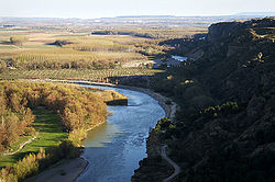
 Aragón river valley in the Huesca province | |
 Watershed of the Aragón (in dark yellow) | |
| Location | |
| Country | Spain |
| Physical characteristics | |
| Source | |
| • location | Central Pyrenees |
| Mouth | |
• location | Ebro River |
| Basin features | |
| Progression | Ebro→ Balearic Sea |
The Aragón (Spanish: Río Aragón; Basque: Aragon Ibaia) is a river in northern Spain, one of the left-hand tributaries of the river Ebro. It rises at Astún (province of Huesca) in the central Pyrenees Mountains, passes southwest through Jaca and Sangüesa (Navarre), and joins the Ebro at Milagro (Navarre), near Tudela. The name Aragón is related to the birth area of the former kingdom, which corresponds to the modern autonomous community of Aragón in Spain.
Watershed
[edit]The river, used for irrigation and hydroelectric power, is about 129 kilometres (80 mi) long; its chief tributary is the Arga River.[1]

Ecology
[edit]Non-government sanctioned re-introduction of Eurasian beaver (Castor fiber) in Spain around 2003 has resulted in tell-tale beaver signs documented on a 60-kilometre (37 mi) stretch on the lower course of the Aragón River and the area adjoining the Ebro River in Aragon, Spain.[2]
References
[edit]- ^ "Aragon River". Encyclopædia Britannica. Retrieved 2012-09-03.
- ^ Juan Carlos Cena; et al. "Castor Europeo en Navarra y la Rioja" (PDF). Galemys. 2: 91–98. Retrieved 2012-09-03.[permanent dead link]
See also
[edit]42°36′23″N 1°03′29″W / 42.60648°N 1.05812°W
