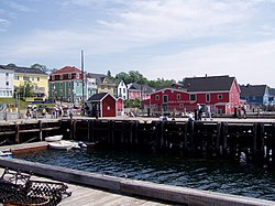
Lunenburg County, Nova Scotia
Lunenburg County | |
|---|---|
 Lunenburg harbourfront | |
| Nickname: "Christmas Tree Capital of the World"[1] | |
 Location of Lunenburg County, Nova Scotia | |
| Coordinates: 44°30′N 64°30′W / 44.5°N 64.5°W | |
| Country | Canada |
| Province | Nova Scotia |
| District municipalities | Chester / Lunenburg |
| Towns | Bridgewater / Lunenburg / Mahone Bay |
| Established | August 17, 1759 |
| Divided into District Municipalities | April 17, 1879 |
| Electoral Districts Federal | South Shore–St. Margaret's |
| Provincial | Chester-St. Margaret's / Lunenburg / Lunenburg West |
| Area | |
| • Land | 2,906.47 km2 (1,122.19 sq mi) |
| Population | |
| • Total | 48,599 |
| • Density | 16.7/km2 (43/sq mi) |
| Time zone | UTC-4 (AST) |
| • Summer (DST) | UTC-3 (ADT) |
| Area code | 902 |
| Dwellings | 24,786 |
| Median Income* | $43,257 CDN |
| |
Lunenburg County is a historical county and census division on the South Shore of the Canadian province of Nova Scotia. Major settlements include Bridgewater, Lunenburg, and Mahone Bay.
History
[edit]Named in honour of the British king who was also the duke of Brunswick-Lüneburg, it was established in 1759, when the Nova Scotia peninsula was divided into five counties. The county became smaller when new counties were created from its boundaries: Queens (1762), Hants (1781), Shelburne (1784), and Sydney (1784).
By Chapter 52 of the Statutes of 1863, Lunenburg County was divided into two districts for court sessional purposes – Chester and Lunenburg. That statute provided authority for the appointment of a Custos Rotulorum and for the establishment of a general sessions of the peace for the District of Chester, with the same powers as if it were a separate county. In 1879, the two districts were incorporated as district municipalities.
Governance
[edit]Today the county has no legal status, although its borders are coincident with the five municipalities contained within it:
- the municipality of the District of Chester
- the municipality of the District of Lunenburg
- the town of Bridgewater
- the town of Lunenburg
- the town of Mahone Bay
The above municipalities comprise the entire territory of the county.[4]
There are three Sipekneꞌkatik First Nation reserves in the county:
Demographics
[edit]As a census division in the 2021 Census of Population conducted by Statistics Canada, Lunenburg County had a population of 48,599 living in 22,443 of its 27,092 total private dwellings, a change of 3.1% from its 2016 population of 47,126. With a land area of 2,906.47 km2 (1,122.19 sq mi), it had a population density of 16.7/km2 (43.3/sq mi) in 2021.[5]
|
Mother tongue language (2011)[8]
|
Ethnic Groups (2006)[9]
|
Religious make-up (2001)[10]
|
Access routes
[edit]Highways and numbered routes that run through the county, including external routes that start or finish at the county boundary:[11]
|
|
See also
[edit]- List of communities in Lunenburg County, Nova Scotia
- List of communities in Nova Scotia
- Lunenburg English, the distinctive dialect of the area
References
[edit]- ^ "Terry's off".
- ^ a b "2006 Statistics Canada Community Profile: Lunenburg County, Nova Scotia". Archived from the original on 2011-07-06. Retrieved 2009-10-04.
- ^ [1] Population and dwelling counts, for Canada and census subdivisions (municipalities), 2006 and 2001 censuses - 100% data
- ^ Municipal Government Act
- ^ "Population and dwelling counts: Canada and census divisions". Statistics Canada. February 9, 2022. Retrieved April 2, 2022.
- ^ Censuses 1871-1941
- ^ Statistics Canada: 1996, 2001, 2006 census
- ^ Statistics Canada: 2011 census
- ^ 2006 Statistics Canada Census Ethnocultural Portrait of Canada: Lunenburg County, Nova Scotia
- ^ [2] Religious make-up, for Lunenburg County, 2001 census - 100% data
- ^ Atlantic Canada Back Road Atlas ISBN 978-1-55368-618-7 Pages 78-80, 86-87
