Asahi, Hokkaido
Appearance
You can help expand this article with text translated from the corresponding article in Japanese. (June 2022) Click [show] for important translation instructions.
|
Asahi
朝日町 | |
|---|---|
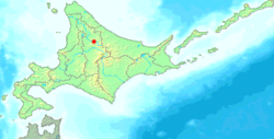
 Location of Asahi in Hokkaido (Kamikawa Subprefecture) | |
| Coordinates: 44°7′N 142°35′E / 44.117°N 142.583°E | |
| Country | Japan |
| Region | Hokkaido |
| Prefecture | Hokkaido (Kamikawa Subprefecture) |
| Now part of Shibetsu | September 1, 2005 |
| Area | |
| • Total | 522.01 km2 (201.55 sq mi) |
| Population (2004) | |
| • Total | 1,799 |
| • Density | 3.45/km2 (8.9/sq mi) |
| Time zone | UTC+09:00 (JST) |
| City hall address | 10 of 4040 Central, Asahi-cho, Kamikawa-gun, Hokkaido 095-0492 |
| Website | web |
| Symbols | |
| Flower | Rhododendron dauricum |
| Tree | Picea glehnii |
Asahi (朝日町, Asahi-chō) was a town located in Kamikawa (Teshio) District, Kamikawa Subprefecture, Hokkaido, Japan.
As of 2004, the town had an estimated population of 1,799 and a density of 3.45 persons per km2. The total area was 522.01 km2.
On September 1, 2005, Asahi was merged into the expanded city of Shibetsu.
History
[edit]- 1949: Asahi village was split from Kamishibetsu village (now Shibetsu city).
- 1962: Asahi village became a town.
- 2005: Asahi village merged with Shibetsu city.
Climate
[edit]| Climate data for Asahi, Hokkaido (1991−2020 normals, extremes 1977−present) | |||||||||||||
|---|---|---|---|---|---|---|---|---|---|---|---|---|---|
| Month | Jan | Feb | Mar | Apr | May | Jun | Jul | Aug | Sep | Oct | Nov | Dec | Year |
| Record high °C (°F) | 8.3 (46.9) |
12.5 (54.5) |
15.8 (60.4) |
26.6 (79.9) |
32.8 (91.0) |
36.4 (97.5) |
36.9 (98.4) |
37.2 (99.0) |
32.0 (89.6) |
25.6 (78.1) |
20.3 (68.5) |
12.4 (54.3) |
37.2 (99.0) |
| Mean daily maximum °C (°F) | −3.9 (25.0) |
−2.8 (27.0) |
1.8 (35.2) |
9.4 (48.9) |
17.5 (63.5) |
22.1 (71.8) |
25.6 (78.1) |
25.6 (78.1) |
21.2 (70.2) |
13.9 (57.0) |
5.3 (41.5) |
−1.6 (29.1) |
11.2 (52.1) |
| Daily mean °C (°F) | −8.0 (17.6) |
−7.4 (18.7) |
−2.9 (26.8) |
3.9 (39.0) |
10.9 (51.6) |
15.8 (60.4) |
19.7 (67.5) |
20.0 (68.0) |
15.2 (59.4) |
8.3 (46.9) |
1.5 (34.7) |
−5.0 (23.0) |
6.0 (42.8) |
| Mean daily minimum °C (°F) | −13.2 (8.2) |
−13.3 (8.1) |
−8.5 (16.7) |
−1.6 (29.1) |
4.5 (40.1) |
10.1 (50.2) |
14.8 (58.6) |
15.4 (59.7) |
10.0 (50.0) |
3.4 (38.1) |
−2.3 (27.9) |
−9.3 (15.3) |
0.8 (33.5) |
| Record low °C (°F) | −28.8 (−19.8) |
−29.0 (−20.2) |
−27.0 (−16.6) |
−14.7 (5.5) |
−4.8 (23.4) |
−0.7 (30.7) |
3.5 (38.3) |
4.6 (40.3) |
0.1 (32.2) |
−5.8 (21.6) |
−17.1 (1.2) |
−26.3 (−15.3) |
−29.0 (−20.2) |
| Average precipitation mm (inches) | 48.2 (1.90) |
37.1 (1.46) |
47.3 (1.86) |
49.4 (1.94) |
69.5 (2.74) |
73.1 (2.88) |
139.2 (5.48) |
149.1 (5.87) |
151.0 (5.94) |
123.1 (4.85) |
104.8 (4.13) |
76.2 (3.00) |
1,067.9 (42.04) |
| Average precipitation days (≥ 1.0 mm) | 17.2 | 13.8 | 14.5 | 11.6 | 11.5 | 9.7 | 11.3 | 11.9 | 13.5 | 16.4 | 19.0 | 20.0 | 170.4 |
| Mean monthly sunshine hours | 59.5 | 77.8 | 117.3 | 154.4 | 193.1 | 172.5 | 166.1 | 156.4 | 151.2 | 118.6 | 53.3 | 38.1 | 1,460.6 |
| Source: JMA[1][2] | |||||||||||||
References
[edit]- ^ 観測史上1~10位の値(年間を通じての値). JMA. Retrieved March 1, 2022.
- ^ 気象庁 / 平年値(年・月ごとの値). JMA. Retrieved March 1, 2022.
External links
[edit]- Shibetsu official website (in Japanese)


